UN Backs Equal Earth Map Projection to Better Represent Africa’s True Size
REPORTED BY FACTHABOURNEWS
The United Nations General Assembly has backed a proposal promoting the use of the Equal Earth map projection, a development that has renewed global attention on how conventional world maps represent the size of Africa and other continents.
The resolution, led by Togo, calls for greater use of map projections that represent the relative size of land areas more accurately. It is aimed at improving geographical representation in education, public information and other areas where maps are used to communicate the size and relationship of countries and continents.
The development has generated considerable interest because of long-standing concerns about the way the widely known Mercator projection represents landmasses.
The United Nations General Assembly’s decision does not mean that the Mercator projection has been officially banned or that every existing world map must immediately be replaced.
Instead, the resolution promotes the use of equal-area map projections, including the Equal Earth projection, where accurately representing the relative size of continents and countries is important.
The resolution reportedly received overwhelming support, with 164 countries voting in favour, one voting against and six abstaining.
The initiative was led by Togo and received support from African countries and other members of the international community.
The debate surrounding the resolution is partly connected to the way maps influence people’s understanding of geography. A map is necessarily a representation of the Earth’s three-dimensional surface on a two-dimensional sheet or screen, meaning that some form of distortion is unavoidable.
Different map projections therefore make different compromises involving size, shape, distance or direction.
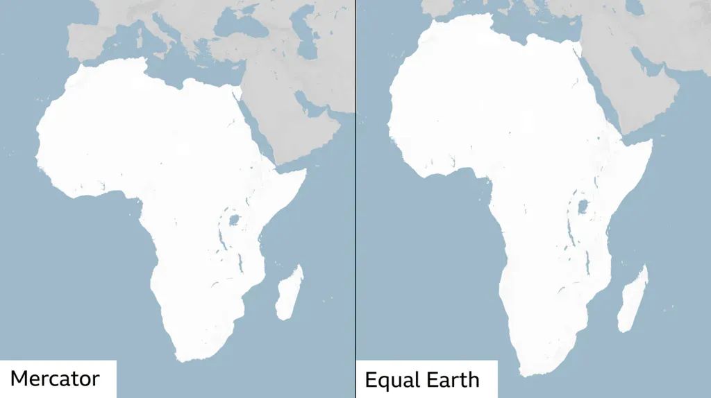
On a traditional Mercator world map, countries and regions located farther from the Equator appear increasingly enlarged. This is because the projection was designed primarily to preserve directions and angles, making it particularly useful for navigation.
As a result, northern regions can appear substantially larger than their actual land area.
Africa, by contrast, extends across much of the world’s tropical and subtropical regions and is centred much closer to the Equator.
When the continents are compared using their actual surface areas, the difference becomes striking.
Africa covers approximately 30.3 million square kilometres, making it one of the largest continents on Earth. Greenland, despite appearing very large on many Mercator maps, has an area of roughly 2.2 million square kilometres.
That means Africa is approximately 14 times larger than Greenland.
The Equal Earth projection was specifically designed to preserve relative areas while producing a visually balanced representation of the world.
The Equal Earth projection is a relatively modern world map projection developed to show continents and countries according to their actual relative areas.
Unlike the Mercator projection, an equal-area projection does not attempt to preserve angles everywhere on the map.
Instead, its principal objective is to ensure that the size of regions on the map corresponds more closely to their actual size on Earth.
This makes equal-area projections particularly useful when maps are being used to compare the geographical extent of countries, continents, vegetation zones, populations or other area-based information.
The Equal Earth projection also attempts to maintain a visually familiar appearance while reducing some of the extreme size distortions associated with cylindrical projections such as Mercator.
Despite the renewed discussion, experts generally do not regard the Mercator projection as simply a “wrong” map.
Its purpose is different.
The Mercator projection was developed in the 16th century and became extremely important for navigation because it preserves local angles and makes constant compass bearings appear as straight lines.
That property made it highly valuable for maritime navigation.
The problem occurs when the Mercator projection is used to compare the actual sizes of countries and continents.
For that purpose, an equal-area projection is generally more appropriate.
Consequently, the UN-backed initiative should be understood as a push for better map choices depending on the purpose, rather than an attempt to declare the Mercator projection obsolete.
For African countries, the development has symbolic and educational significance.
Africa is the world’s second-largest continent by land area and contains 54 internationally recognised sovereign states. Yet its geographical scale can be underestimated when people primarily encounter highly distorted world maps.
Using equal-area maps in classrooms, textbooks, digital platforms and public information materials can provide students and the wider public with a better understanding of Africa’s geographical size.
It can also make comparisons between Africa and other parts of the world easier to understand.
The issue is therefore not simply about changing the appearance of a map. It is also about improving geographical literacy and ensuring that visual representations do not unintentionally create misleading impressions about the relative size of regions.
The UN resolution does not mean that the Mercator projection will disappear from the internet, navigation systems or educational materials overnight.
The projection remains useful for specific applications, particularly navigation and mapping systems where preserving angles and directions is important.
Instead, the UN initiative encourages broader consideration of equal-area alternatives when the objective is to communicate the true relative size of geographical areas.
The Equal Earth projection is one such alternative.
The UN General Assembly’s backing of the proposal has therefore renewed a long-running discussion among cartographers, educators and geographers about how the world should be represented.
There is no single map projection that can perfectly display the Earth’s curved surface on a flat page without distortion.
The most appropriate projection depends on what the map is intended to show.
For comparing the relative size of continents, however, an equal-area projection such as Equal Earth can provide a more accurate visual impression than Mercator.
The development is consequently significant not because the United Nations has abolished the traditional world map, but because it has placed greater international attention on accurate geographical representation.
For Africa, the discussion is particularly important because the continent’s enormous geographical scale is often visually underestimated when using projections that enlarge areas near the poles.
As schools, governments, media organisations and digital platforms consider how they present geographical information, the growing interest in Equal Earth could lead to more widespread use of maps that communicate the relative size of continents more faithfully.
Reported By Facthabournews
